
As a keen hiker and photographer, the Horseshoe Ridge Trail in the Brecon Beacons National Park in mid Wales in the United Kingdom is one of my favourites. On the trail you have the opportunity of climbing three or even four peaks in one looping hike, which ranges between 8 and 10 miles.
For any photographer the trail is a dream, with so many spectacular views, when the weather behaves. There are some tough ascents and so you need to be physically prepared and wearing the right kit. Waterproofs, water, food and a map are as essential as your mobile phone! If the weather forecast is okay, I will take one of my Canon cameras along with plenty of waterproof covers and lens cleaners. If I take my Canon 90D or 6D, I use a chest harness where the camera sits in the centre of my breast bone. This keeps my hands and arms free and prevents me walking with a camera strapped across one shoulder and knocking against my hip.
What I love about the Brecon Beacons is the unexpected bonus of a stunning photo opportunity after hours of trudging along in low cloud. You’ve just got to be ready to get the shot when the time arises, no matter how brief. Along the route are some of the most amazing views of this part of the Brecon Beacons and, on a clear day, you can see for miles.
The Route
The Horseshoe Ridge Trail takes you up and along the Graig Fan Ddu ridge, over the peaks of Corn Du, Pen-y-Fan and Cribyn, and then back to the start along the Gap Road. There are some tough climbs, technical descents, and breath-taking vistas.
- Distance: approximately 8.6 miles (13.8 km)
- Elevation gain: plus 2,000 feet (610 m)
- Time: approximately 4 hours for regular hikers
I’ve put together a collection of photographs from the last three times I have walked the route – once at the end of the summer and twice in the winter. The photographs have been taken using a Canon 90D, Canon IXUS510 HS, and my Samsung Galaxy A32. When the weather is really bad, I tend to revert to the Canon IXUS510 HS and my mobile phone (housed in a waterproof cover). Digital cameras and water don’t mix.
The gallery of photographs is not meant to be the best-ever photographs of the area, but illustrate the variability of the conditions – terrain and weather. On the map I have noted where I took each photograph (with a capital letter) and this corresponds with the letter at the start of each photograph’s file name.
The photographs show that you need to be well prepared. Taking on Pen-y-Fan from this direction is not as straight forward as the most traditional busy route from the A470. I have bumped into people wearing completely the wrong clothes, no provisions, and who had no real idea of where they were going (I am often asked “Where is Pen-y-Fan from here?”). Keeping safe and healthy means enjoying this wonderful trail to the full.
The Start
I tend to start off in Neuadd Car Park just down from the Lower Neuadd Reservoir. Once you join the road, you walk slightly uphill along the road and then track (north-north-west) for around 0.6 miles (1 km) until you reach the Lower Neuadd Reservoir. Once you’ve negotiated your way around the building works, you cross the water and have your first fantastic view of the walk ahead.
The First Climb
By the time you reach the first climb, you’ll have warmed up – and you’ll need to be! Now heading west, you are faced with a steep ascent, stretching 0.6 miles (950 m), up and onto the Graig Fan Ddu ridge. Although the path has been fantastically maintained by the National Trust (as most of the paths on this route), it is comprised of uneven stone steps. Nearer the top there is quite a bit of erosion and extra care is needed in the wet. Once you get to the top of the climb, take a breath and just enjoy the view. It is spectacular.
To the north you will see your way forward and the peaks of Corn Du, Pen-y-Fan and Cribyn. To the east, is Gwaun Cerrig Llwydion and to the south, there are views over Pontsticill Reservoir towards Merthyr Tydfil.
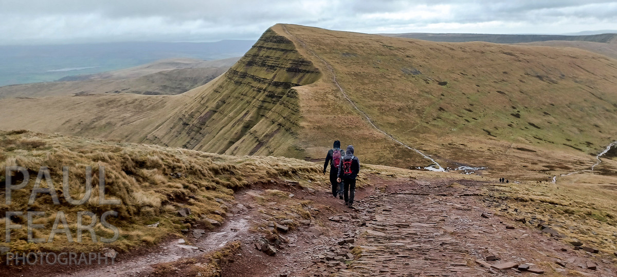
Walking the Graig Fan Ddu Ridge
I have walked the 2.7 mile (4.3 km) along the ridge to Corn Du in blistering sunshine, pouring rain, and with gale force winds knocking me off my feet. Every time is a different experience. When the conditions are difficult, especially in high winds or when there is low visibility, care is needed. This is not a walk for the faint hearted or under-prepared.
The views as you walk along the ridge are amazing. As a photographer, I have to force myself to put my camera away and carry-on walking. Even in poor weather, when the views were so changeable, winds can sporadically whip away the clouds to expose the mountains ahead.
Corn Du and Pen-y-Fan
Nearly 4 miles (6.4 km) into the walk and you join the walkers coming up from the main Pen-y-Fan car park on the A470. The path up to the plateaued top of Corn Du is steep and you will need your hands to help you get up. The flat top takes you across to a spectacular view looking down on the Llyn Cwm Llwch upland glacial moraine lake to the north-east, Y Gyrn, Fan Fawr, Mynydd Du to the west, and the town of Brecon to the north. There are also wonderful views of Pen-y-Fan’s sweeping mountain sides, carved out of the rock by glaciers during the last ice-age.
Corn Du stands at 873m (the second highest peak in the Brecon Beacons) and the summit is marked by a Bronze Age cairn with a central burial cist, similar to one on nearby Pen y Fan.
After the obligatory photographs on Corn Du, you drop down a well-maintained path, before climbing back up to the plateau and the top of Pen-y-Fan. The views from the top are incredible, with Corn Du behind you and your next peak Cribyn ominously appearing in the east. Pen-y-Fan is the highest mountain in the Brecon Beacons and the southern UK standing at 886m.
The top is usually busy, even in poor weather. The National Trust is continuously maintaining and repairing the well-worn paths, with more people than ever climbing the mountain. After another obligatory photograph holding onto the Pen-y-Fan sign at the peak, you leave the plateau and start the difficult descent, heading towards the third peak.
Cribyn, the Third Peak
The stone-pitched path leading down from the peak must be tackled with care. It is easy to turn an ankle or take a tumble, especially as your legs will now feeling the effects of your endeavours. As you descend, Cribyn ominously appears to grow in height. At the bottom of the slope, where the terrain levels out into a saddle, the peaty ground is often waterlogged and boggy. It’s time to stop and take on some food and water, whilst taking in the view of Cribyn, looming above you. You can also marvel at the Graig Fan Ddu ridge, where you have just walked.
The steep climb to the top of Cribyn is around 0.35 miles (570m), ascending around 380 feet (115 m). Once again, the National Trust has laid stones into the path to reduce wear, which helps especially when the weather is particularly wet. In heavy rain, the path can turn into a stream of water.
Cribyn stands at 2608 feet (795 m), with a long and impressive escarpment facing north towards Brecon. Most people stop after reaching the peak of Pen-y-Fan, but I always find the best views are from the cairn on the top of Cribyn. You can see the long smooth slopes of Pen-y-Fan sweeping down to the Cwm Sere valley floor and trace back the steep stone-laden path you have just walked from the peak to the saddle. To the south east is another peak, Fan-y-Big, and a long sweeping ridge that leads down to the town of Brecon.
Gap Road Walk
The 0.8 miles (1.3 km) path along the ridge running down from Cribyn is very boggy and steep in places. After a long trek you reach the bottom of the ridge where you have two options. You could climb up to the top of Fan-y-Big and add peak four to the three already conquered, or follow the Gap Road back to the car park.
I have always thought that the Gap Road was an old Roman road, but have since learned that there is no archaeological evidence. However, this road is of historical importance, being the first track to enable horse-drawn carriages to cross the mountain range from the town of Brecon.

The panoramic views, as you walk along the track, allow you to fully appreciate the Horseshoe Ridge Trail. You can take pride in conquering three (or even four) peaks. The track is pretty stony and good footwear is essential, especially in the wet. The walk from the bottom of the Cribyn ridge to the car park is a long-old drag, covering 4.4 miles (3.8 km). However, those spectacular views take your mind off any sore feet or aching legs.
When I set off early in the morning (8am latest), the car park was nearly empty. By the time I return, it is normally packed. As you take the rucksack off your back, enjoy the moment. You will have just conquered three of the highest peaks in the southern United Kingdom. And you will a set of amazing photographs.
Paul Fears is a commercial and industrial photographer based in South Wales. He is also a keen walker and has taken on several challenges including the Welsh 3 Peaks, the 5in55, 10nTaff and BikeBoatBoot to raise funds for Ty Hafan. He is presently training for a new challenge in 2025 – Everest Base Camp, where he will be accompanied by one of his son’s favourite cuddlies, Snowdog,


Pingback: topical ivermectin
Pingback: sertraline hcl 25 mg cost
Pingback: esomeprazole 20mg capsule
Pingback: finasteride dea schedule
Pingback: sildenafil tablet amazon
Pingback: does doxycycline treat bacterial infections
Pingback: metronidazole brand name philippines
Pingback: minoxidil near me
Pingback: terbinafine key facts